Urban Designer crandall arambula - pORTLAND

Transit Oriented Development + Mobility Oriented Development
Crandall Arambula allowed me to witness the role that design plays in shaping a more sustainable and exceptional future. I gained a holistic understanding of sustainable urban design and community engagement by working closely with principals to translate complex issues and concepts into meaningful, understandable solutions. As a graphics coordinator and primary graphics producer, I collaborated with multiple teams to create public involvement presentations, table maps, survey ballots, and final documents. My work spanned a variety of projects, including Redevelopment Plans and Station Area Plans, each contributing to thoughtful community development and improved transit accessibility.
district planning Heritage district redevelopment plan
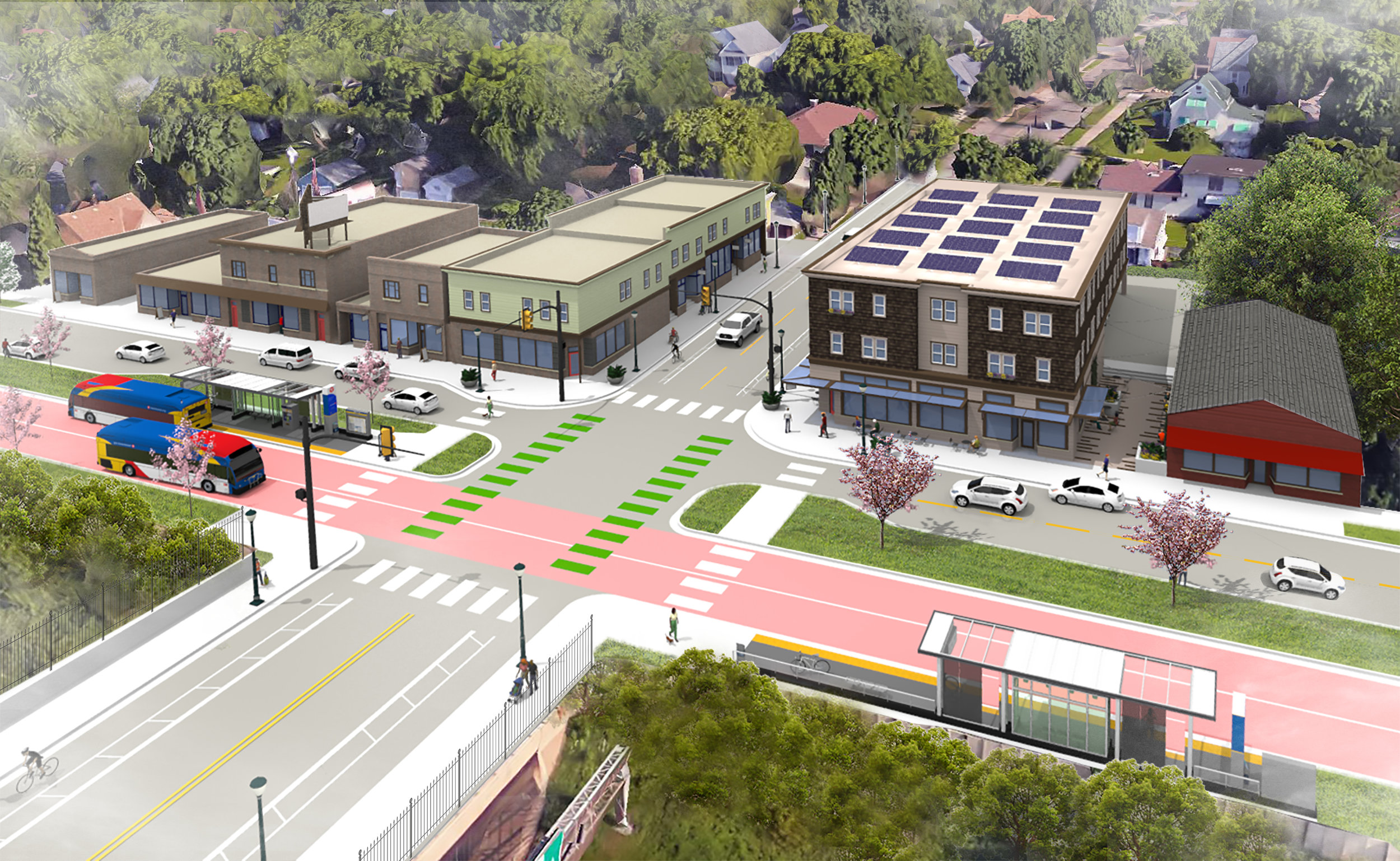
Over the last decade, the town of Gilbert, AZ strategically acquired land in preparation for the anticipated commuter rail station that will link the community directly to downtown Phoenix. This foresight led to the development of the Heritage District Redevelopment Plan, shaped through an inclusive and rigorous process involving public engagement and collaboration with local stakeholders and community groups.
The plan addresses critical needs for public space, multimodal circulation, and functional civic and retail environments. At its core, the proposal envisions a dense urban center anchored by a vibrant plaza. Surrounding this focal point is an arcade-lined retail street designed to encourage pedestrian activity, complemented by a new residential neighborhood that embraces transit-oriented development principles.
Central to the plan is the integration of a well-connected commuter rail station, enhancing regional accessibility. To promote seamless movement, the design includes car-free circulation routes that traverse the district uninterrupted both north-south and east-west. Additionally, modifications to the local street network aimed to alleviate traffic congestion involved linking a frequently congested road to another nearby street. This change not only improves traffic flow but also activates the proposed retail corridor, fostering a lively and accessible commercial environment.
The Heritage District Redevelopment Plan thus represents a thoughtful, community-driven approach to urban design, balancing transit connectivity, livability, and economic vitality for Gilbert’s future growth.


Collaborating closely with fellow urban designers and planners, I engaged with the project from its earliest conceptual stages. My contributions spanned across public involvement, design development, thorough documentation, plan adoption, and developer selection processes. By translating initial sketches and drawings into detailed 3D models, I crafted pedestrian-centric streetscapes, shady arcades, and illustrative massing that brought the vision to life. These models ranged from aerial buildout perspectives to intricate sections of critical infrastructure, each designed to produce dynamic, compelling, and believable visuals. This experience underscored the importance of strategically positioning individual infill developments to foster a more resilient and dynamic urban fabric.


Shortly after the adoption of the Heritage District Redevelopment Plan, the city of Gilbert, AZ selected a development team to realize the North Anchor. Serving as the terminus of the uninterrupted pedestrian and cyclist path known as the Paseo, the North Anchor is a critical first phase that sets the tone and character for all future developments along the route.
The initial design proposal depicted the Paseo as a generic landscaped sidewalk, which did not fully capture the vision or potential of this vital public space. In response, the Heritage District Redevelopment Administrator requested additional illustrative materials to better convey design intent and facilitate targeted feedback.
To address this request, I developed a series of detailed models and illustrations showcasing an idealized scene that emphasized the essential design elements of the Paseo. These visuals adhered closely to the project’s preferred massing and respected the existing site conditions. They also proposed thoughtful design solutions, such as ensuring the architectural language of the parking garage complemented that of the adjacent office building.
These illustrations proved instrumental for the Implementation Committee, providing a clear and tangible means to communicate their priorities and aspirations to other design team members. As a result, they fostered alignment across stakeholders and helped guide the development of the North Anchor into a cohesive, context-sensitive gateway for the Heritage District Redevelopment Plan.


Transit Oriented Development station area planning
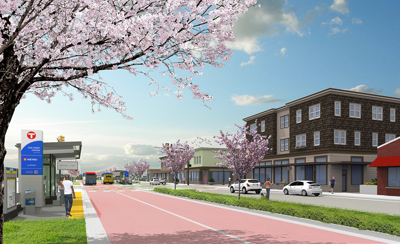
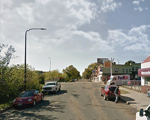
A significant portion of my time at Crandall Arambula was dedicated to designing and illustrating two Bus Rapid Transit (BRT) lines connecting to St. Paul, MN. Working closely with urban designers and planners, I contributed to the project from its early conceptual planning stages through to public involvement, design development, documentation, and final adoption.
My role involved translating early sketches and diagrams into detailed 3D models alongside conventional technical drawings. This process helped bridge the gap between abstract ideas and the practical realities of the built environment. Using these models, I produced a range of public-facing graphics—from clear, illustrative maps to more evocative perspective renderings—to effectively communicate the project’s vision and benefits.
The project presented the challenge of creating safe, accessible, and transit-supportive environments within a low-density context, demanding a rigorous and fast-paced approach to transit-oriented design. This experience taught me how to apply sound urban design principles where conditions are less than ideal, and how to engage the public meaningfully through straightforward and honest visual communication.
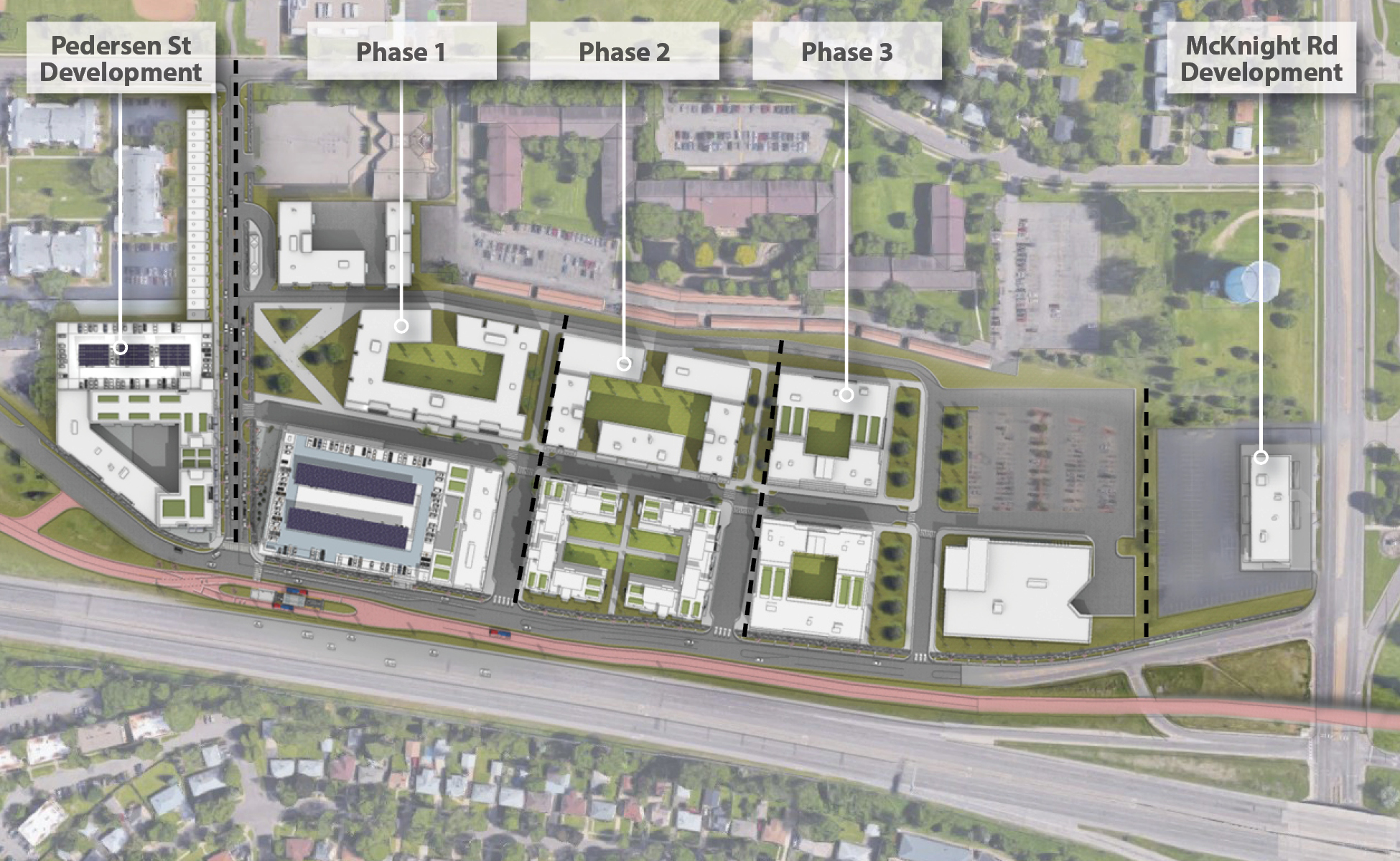
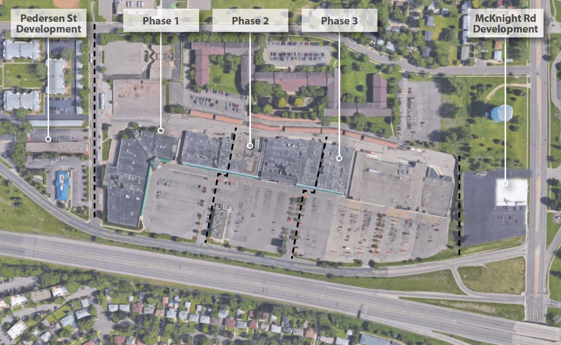
The station area plans developed and adopted for the Gold Line will guide future development around the transit stations, helping to shape sustainable and connected neighborhoods that support transit use over time.


Many of the stations along this alignment of the Gold Line BRT route were located at shopping centers with overly large parking lots. These stations presented an opportunity to develop new typologies for adapting underused strip mall style developments into dense, transit supportive communities.